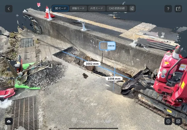
At civil engineering construction sites, we often hear comments such as , “Even though we go to the trouble of taking 3D measurements, we still end up delivering traditional drawings,” or “3D data is treated merely as reference material, and maintaining two separate sets of data is the norm.”
While there is a growing call for on-site efficiency and digital transformation (DX), we would like to introduce a case study of the Ehime Prefecture Public Works Department’s efforts to address the challenge of “measurements have become easier, but the workload hasn’t decreased.”
In October 2025, the Ehime Prefecture Department of Public Works revised and published the “Guidelines for the Implementation of ICT-Based Construction Projects (Latest Edition).”
These guidelines position the use of 3D data—from initial surveying through construction management to the final delivery of deliverables—as a “standard business process” for public works projects. They clearly state that 3D data (including point cloud data acquired via 3D scanners, LiDAR sensors, etc.) can be utilized and electronically delivered as official deliverables.
With the official announcement of a shift away from traditional drawing-centric operations—without requiring dual management—a future is now in sight where the convenience of 3D scan data, previously viewed as “useful but difficult to use for delivery” or “ultimately requiring dual management alongside conventional methods,” will directly lead to labor savings on-site.
↓↓↓ Click here for the full text of the Ehime Prefecture ICT Guidelines ↓↓↓
https://www.pref.ehime.jp/page/8140.html
For ICT-based construction projects in Ehime Prefecture, the following process is generally followed.
Scanat can be utilized in processes such as "3D pre-construction surveying," "3D as-built management," and "3D data delivery,"opening up new possibilities for completing the entire process from as-built management and inspection to final delivery.
Point cloud data and 3D models captured using these devices are also eligible for electronic delivery as construction as-built documentation, provided certain conditions are met.
① Suited for the Era of Surface-Based Management
The new ICT guidelines have established “surface-based as-built management”—which ensures sufficient point density—and pass/fail determination using heatmaps as standard practices, moving away from the traditional “cross-section and point” approach.
Scanat excels at 3D scanning that captures the entire site as a surface, making it highly compatible with this management approach.
Numerous benefits can be expected, including reduced effort in creating management documents, streamlined inspection processes, and improved explanatory power through site visualization.
② 3D Technology Officially Approved for Small-Scale Construction and Repair Projects
Under these guidelines, the use of ICT-based surveying has been expanded to include small-scale construction projects.
Even without expensive laser scanners or UAVs, as-built management using mobile devices or ground-based photogrammetry is now officially recognized for work categories such as ICT earthwork (less than 1,000 m³) and ICT paving work (repair work).
This lowers the barrier posed by the notion that “3D measurement is impossible without expensive equipment , ” making it possible to utilize accessible 3D scanning technologies likeScanatwith a view toward final delivery.
③ Cases where 3D data creation is “recognized as an expense”
For contractor-initiated ICT-utilizing construction projects, it is also explicitly stated that costs associated with “3D as-built surveying” and “3D design data creation (including revisions)” can be accounted for as design changes.
As a result,
・3D data creation will no longer be considered “out-of-pocket work”
・The barriers to Scanat and utilizing Scanat will be lowered
These benefits can be expected.
As described above, 3D data captured Scanat is becoming a practical option for ICT-driven construction projects, offering the following benefits:
・Acost-effectivealternative to expensive specialized equipment
・Suitable for small-scale construction and repair projects
・Eliminates duplicate data management
・Technology that supports everything from as-built verification to electronic delivery
Scanat not just about “measuring and calling it a day,” but rather “3D data that can be used all the way through to project delivery.”
As a powerful ally in helping construction companies meet future demands for operational efficiency through mobile LiDAR, customers have expressed high expectations, stating, “If adopted as a proposal-based ICT construction project, it is expected to earn bonus points in construction performance evaluations, leading to a higher probability of winning future contracts.”
The case study from the Ehime Prefecture Public Works Department reflects the policy direction of the Ministry of Land, Infrastructure, Transport and Tourism, and we anticipate that it will be adopted nationwide in the future.
We are committed to supporting companies that wish to quickly adopt this model as a best practice, accumulate expertise, and gain a competitive edge.