
▼ Exhibition Overview
Date and Time: July 8 (Wed) – 10 (Fri), 2026, 10:00 a.m. – 5:00 p.m.
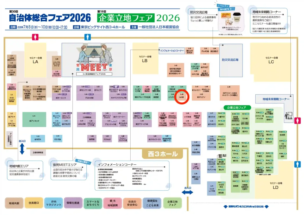
Venue: Tokyo Big Sight , West Hall 3 [L-49] (3-11-1 Ariake, Koto-ku, Tokyo)
Admission: Free (advance registration required)
We will be exhibiting at the “Local Government Comprehensive Fair 2026,” an exhibition held at Tokyo Big Sight for three days from Wednesday, July 8, 2026, to Friday, July 10, 2026, which supports the resolution of regional issues and the advancement of local government management.
This exhibition brings together the latest solutions designed to address the challenges faced by local governments across the country, such as promoting digital transformation in government, strengthening regional disaster preparedness, and extending the lifespan of infrastructure.
In response to challenges such as the worsening labor shortage among local government employees, the need for rapid responses to increasingly severe natural disasters, and the management of aging public facilities, nat proposes a solution to improve operational efficiency using simple 3D scanning technology, under the initiative “Local Government DX and Infrastructure Management Starting with Just One iPhone.”
nat (Live Demos)
At nat, we will be showcasing Scanat,” an app that allows you to record and measure on-site infrastructure and buildings as high-precision 3D data using only your everyday iPhone or iPad—without the need for expensive specialized equipment.
On the day of the event, we will be offering a “live demo” at our booth, where we’ll recreate the target objects so that anyone can easily try 3D scanning right there on the spot. We invite you to come to the venue and experience firsthand the latest technologies supporting smart government.
▼Please pay special attention to this section
・Rapid assessment of disaster sites: Instantly capture 3D data of the shape and scale of affected areas, including slopes. This prevents the need for re-surveys due to measurement omissions and speeds up the creation of data required for recovery plans and reports to the government.
・Digital Transformation (DX) for Infrastructure and Public Facility Maintenance: Visually document the aging and current condition of roads, slopes, bridges, and public buildings using 3D data and 360-degree panoramas. This allows for the easy sharing and management of field information—which tends to be dependent on specific individuals—within the agency.
・Contactless, Safe On-Site Surveys: Even on steep slopes where entry is dangerous or on roads where traffic restrictions need to be minimized, you can safely and quickly capture data on target objects from a distance.
・Smooth Consensus-Building with Relevant Parties: By utilizing detailed 3D models and dimensional data, we support the creation of visual and easy-to-understand consensus—whether through issuing work orders to contractors, explaining projects to residents, or during internal agency discussions.
◼︎Recommended for people like this
We highly recommend this to local governments, government agencies, and public organizations facing the following challenges.
⚪︎Staff in charge of disaster prevention, crisis management, and urban development (early assessment of disaster damage, creation of hazard maps, and digitization of on-site data)
⚪︎Managers in the Road, Civil Engineering, Construction, and Facility Management Divisions (maintenance and management of public infrastructure; streamlining current condition surveys)
⚪︎Staff members in charge of DX promotion and smart cities (considering the implementation of cost-effective, easy-to-use on-site DX tools)
■ Venue Access Map
Venue: Tokyo Big Sight, West Hall 3 (3-11-1 Ariake, Koto Ward, Tokyo)
Nearest Station: About a 7-minute walk from "Kokusai-Tenjijo Station" on the Rinkai Line
About a 3-minute walk from "Tokyo Big Sight Station" on the Yurikamome Line
nat Booth Location: [L-49]
■Introduction to Exhibited Products
" Scanat," a 3D scanning app
We’re overturning the common belief among local governments that “systems requiring expensive laser scanners and specialized expertise come with high costs and implementation barriers,” and we’re dramatically transforming on-site surveys using just a single, everyday iPhone.
With just one staff member taking a few quick photos, you can measure dimensions within the 3D model, calculate area and volume, and export CAD data (DXF compatible).
From large-scale civil engineering sites to the interiors of public facilities, this solution eliminates the need for return visits due to missed areas, significantly shortening the lead time from survey to planning.
"We want to easily start digitizing our operations on-site with a limited budget and staff."
"We're looking for new DX tools to protect local safety and infrastructure."
We sincerely look forward to seeing you all there.


