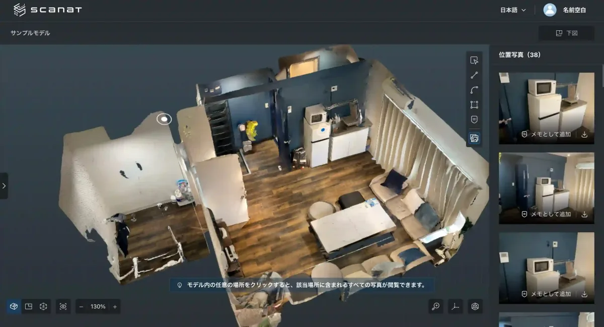
natCo., Ltd. has launched a “location-based photo search feature” for its 3D scanning app “Scanat ,” a “location-linked photo search feature” that automatically searches for and displays corresponding on-site photos simply by long-pressing any point on a 3D model. This feature is now available on both the app and the web.
This marks the first implementation of such a scanning app originating in Japan.
◼︎Background and Challenges
In the construction and infrastructure sectors, the use of 3D scanning to digitize job sites is rapidly gaining traction.
However, since high-resolution photos are taken simultaneously with the scanning process—often amounting to several hundred to several thousand photos per site—there was a challenge in that even a simple task like “viewing the details of areas identified in the 3D model through photos” took an enormous amount of time.
Previously, staff members had to search for the desired photos manually, which was a major bottleneck in improving the efficiency of on-site inspections.
◼︎Overview of New Features
With the newly released "location-based photo search feature, " users can simply click any point on a 3D model to instantly search for and view a list of photos that capture that location.
The photos displayed are automatically ranked using a proprietary algorithm that comprehensively evaluates factors such as compatibility, distance, and angle.
This makes it possible to automatically identify "the photo that best captures this part" without human intervention.
It also includes features for adding notes and annotations to photos taken at the same location, as well as functions for exporting and sharing photos, enabling a seamless workflow from on-site verification to information sharing.
◼︎Three Innovative Benefits of the "Location-Based Photo Search Feature"
・Maximizing search efficiency through “reverse lookup”:
Simply tap (select) any spot in the model that catches your eye, and it will instantly list all photos containing that location.
It completely eliminates the hassle of "searching" through large collections of photos.
・AI-powered prioritization algorithm:
From the set of extracted photos, the system uses a proprietary algorithm to comprehensively evaluate factors such as fit, distance, and angle, and prioritizes displaying the photo that best captures this specific area.
・Multifaceted Use of Information:
You can pin the photo you’ve called up directly as a “note” to a specific location within the model or share it externally.
This helps prevent “misalignment of perspectives” between the field and the office.
◼︎Quantitative Benefits of Digital Transformation in Field Surveys
ScanatWith the introduction of this system, on-site surveys—which previously took 1 to 3 hours with 2 to 3 workers—will be reduced to just 20 minuteswith a single worker.
With the addition of this “location-based photo search feature,” the time spent organizing photos after returning to the office and the effort required to verify details by revisiting sites will be further reduced, dramatically improving overall project productivity.
◼︎Product Details (Operation and Specifications Reference)
This feature is available in both the web browser version and the iOS app.
Detailed specifications and instructions for each environment are provided below.
♢Basic Usage
Supported Modes: 3D Mode, Bird's-Eye View Mode
Recommended scan mode: "Normal Scan"
*Since the floor plan scan mode may fail to match photos with their correct locations in some areas, we recommend using the Normal Scan mode for this feature.
♢Instructions (Web Version)
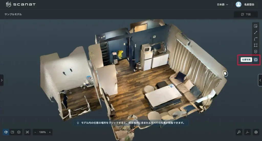
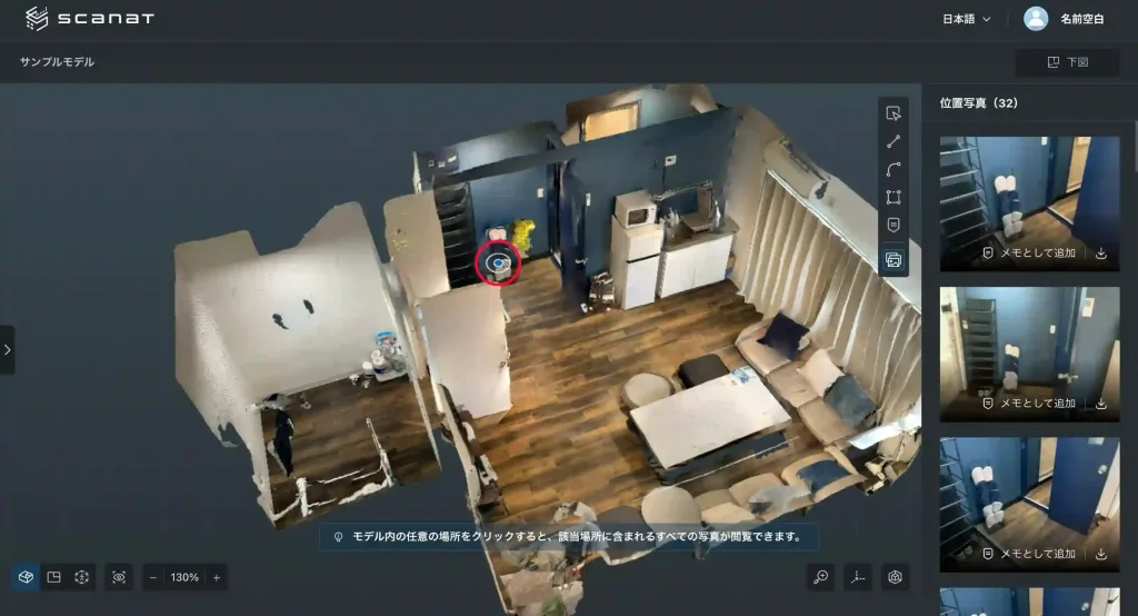
1. Launching the Feature:
Click the "Location Photo" icon on the toolbar on the right side of the model details screen,
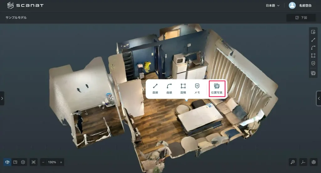
or right-click anywhere on the model and select "Location Photo" from the menu.
2. Specifying a Location
Left-click the location you want to view within the 3D model.

3. Viewing Photos
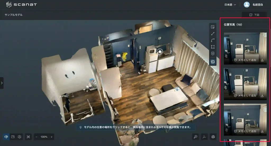
A list of the extracted photos is displayed on the right side of the screen.
You can scroll through the photos using the mouse wheel.
4. Changing the Location
When you click on a different location, the selected location changes, and the list of photos on the right automatically updates with information about the new location.
♢Instructions (App Version)
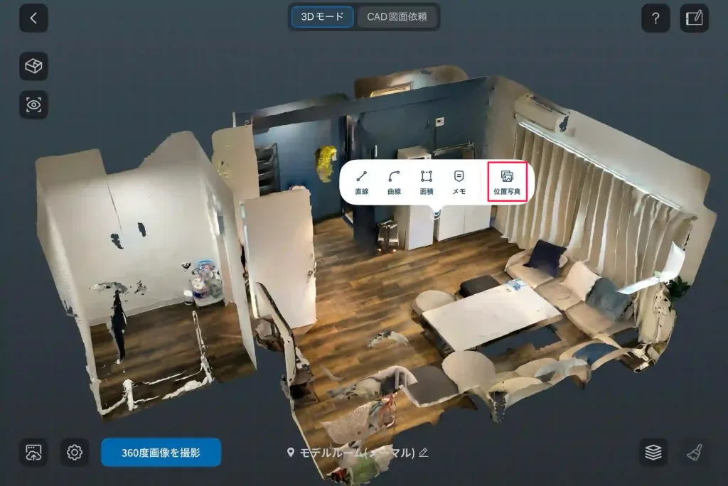
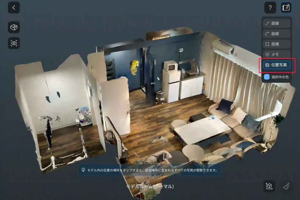
1. Launching the Feature:
Either “long-press” anywhere in the model and select it from the menu, or
enter measurement mode by tapping the “Measure” button in the upper-right corner, then tap the “Location Photo” button.
2. Selecting a Location
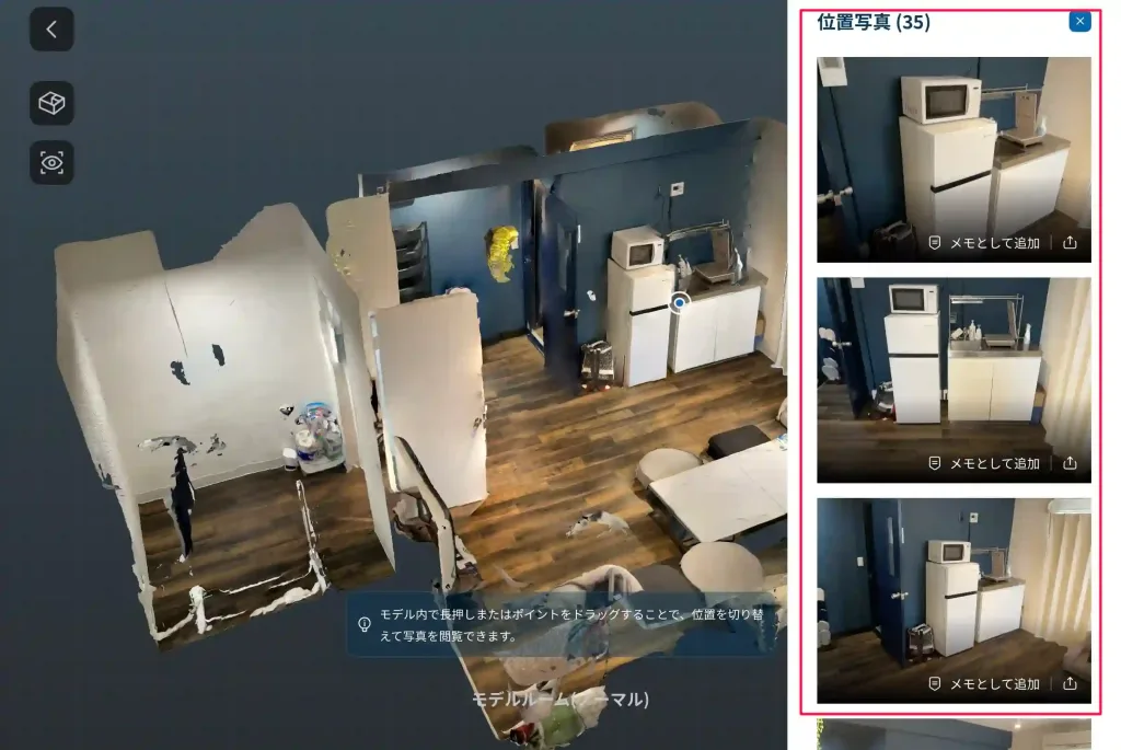
Tap the location you want to check, or drag the currently selected pointer (pin) to move it.

3. Viewing Photos
Swipe up or down on the list displayed on the right to browse.
Tap a photo to switch to enlarged view (preview mode).
♢Practical Steps
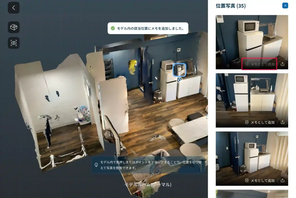
Add as a Note: When you click the "Add as a Note" button in the photo list, a note is created at the corresponding location on the model, and that photo is automatically attached to it.
Download and Share
Web version: You can save the photo to your device by clicking the "Download" button on the photo.
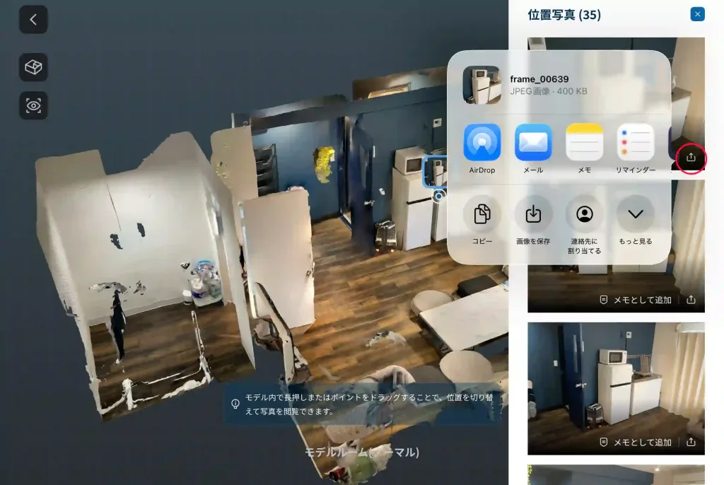
App version: You can select options such as AirDrop, email, or saving the image by tapping the "Share" button.

◼︎Important Notes on Use
Loading data: To ensure high-precision matching, it may take some time to load the data.
Recommended Mode: We recommend using this feature in "Normal Scan" mode. In "Floor Plan Scan" mode, matching may fail in some areas.
Model Editing: If you have made significant edits to the model (such as cropping), the photo and the selected area may not align.
◼︎List of Updates
New Feature: Addition of "Location-Based Automatic Photo Search" (App and Web Versions)
▼Please update the app
To access the new features, please update to the latest version (v2.2.0) using the link below.
(*If you would like to learn how to use the “Location Photo” feature or check whether it’s a good fit for your company’s operations,
please contact us .)