Seminar Announcement
2月21(金) 10:00 〜町田ひろ子アカデミーの会場をお借りして、皆様と同施設内を参加者全員でスキャンを実践、スキャン後、皆様の撮影結果を弊社スタッフが実際の画像を確認しながらアドバイスを提供いたします
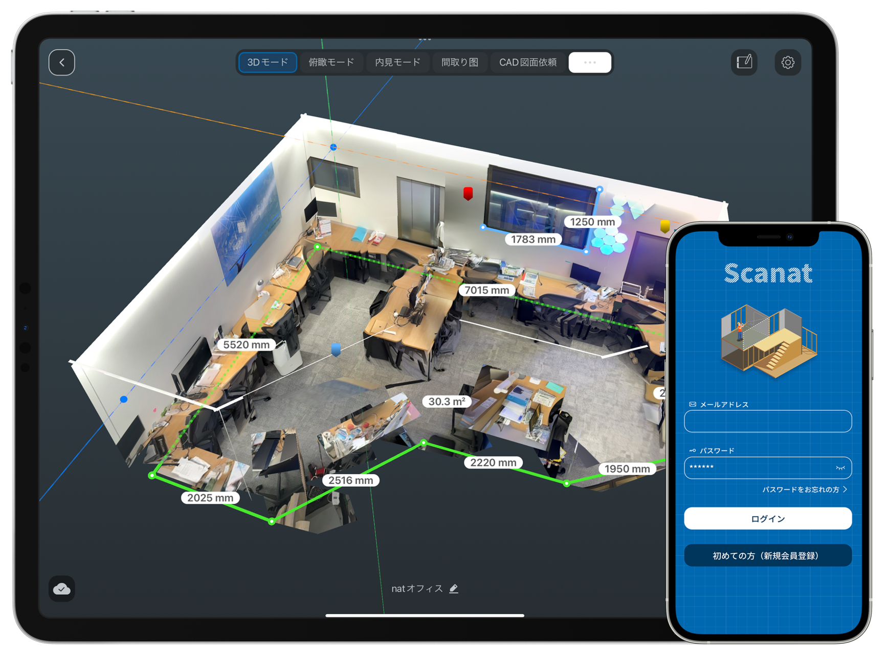
Here are some tips for 3D scanning.
As we introduce 3D scanning technology, we’ll share tips on how to use Scanat, with a focus on techniques for capturing images.
Experiencing Scanning Together with Everyone
We will be using 町田ひろ子 as our venue, where all participants will practice scanning together within the facility.
After the scan, our staff will review the images you captured and provide advice.
―[Session Schedule]――――――――――――――――――――
10:00| 開催のご挨拶 (5分)
10:05| 建築業界での3Dスキャン活用事例の紹介 (30分 )
┗Lidarセンサー技術のトレンド
┗Scanat機能紹介
┗Scanデモ(3D SCANのコツをご紹介)
10:35| Hands-on撮影会 (20分 )
10:55| 撮影結果フィードバック (20分)
11:15 | 3DSCAN撮影にまつわるQA (25分)
11:40 町田ひろ子アカデミーインテリア研修メニューのご案内 (10分)
┗インテリア設計・デザイン提案で活用したいDX仕事術講座のご案内
―[Session Details]――――――――――――――――――――
Click here to apply
What is 3DScan?
3D scanning technology refers to a system that uses devices (3D scanners) to measure the shapes and spaces of real-world three-dimensional objects and convert them into 3D data.
It allows for the capture of shapes and measurements without physically touching the objects.
By capturing the shapes of various objects—such as terrain, buildings, vehicles, and cultural properties—users can view and zoom in or out on objects and spaces from various angles, as well as measure their dimensions. History of 3D Scanners
What Is a 3D Scanner?
A 3D scanner projects light—such as lasers or LEDs—onto an object, captures the time differences and angles of reflection with a camera, and calculates the data to acquire the object’s surface topography as 3D data.
It is characterized by few restrictions based on weight, size, or material, and the ability to quickly convert complex shapes into 3D data.
Facial recognition features on smartphones and LiDAR sensors used in autonomous vehicles are also common examples of 3D scanners.
The Introduction of LiDAR Scanners and Their Integration into the iPhone and iPad
LiDAR has a long history; it is a technology that has been in use since the 1960s, when it was first mounted on aircraft to scan terrain. Since the 1980s, LiDAR has become even more widespread, and data collected from LiDAR scans can now be used to build 3D models.
Lidar Sensors in iPhones and iPads
In 2020, the introduction of the LiDAR scanner in the iPhone 12 Pro made 3D scanners more accessible to the general public.
3D Scan Data Used in Construction Sites
###Although companies considered adopting 3D scanning technology for scanning spaces and sharing data, the need for specialized equipment meant it remained out of reach for many. Furthermore, general-purpose scanners were primarily used for measuring the shapes of terrain (in civil engineering) and large structures (in architecture) as an extension of surveying.
A Breakthrough Brought About by the Introduction of Scanat
Developed to support on-site surveys in fields such as architecture by utilizing the LiDAR sensor scanner built into the iPhone and iPad,Scanat was developed by incorporating feedback from a wide range of users across Japan. It has earned high praise at sites where scanning, saving, and measuring spaces are necessary for on-site surveys and other tasks, and has been adopted by over 550 companies in the nearly three years since its release in 2022.
Organizer Information
nat has launched an AI surveying app that utilizes smartphone LiDAR sensors to address challenges in the digitization of spaces and objectsScanat , a service designed to solve challenges related to the digitization of spaces and objects.
Through tools and platforms that allow anyone to easily share the reality (3D) of everything in the world—such as “spaces” and “objects”—we support increased productivity and the unleashing of creativity.
By creating products that transform daily work and life and implementing them in society, we aim to become an indispensable part of people’s lives and help realize a safe, secure, and prosperous society.


