▼Highlights of This Case Study
また、法改正により正確な高低差データの重要性が増していた。
【リノベ】現地確認〜提案の間に、確認漏れによる再訪問が多発していた。
導入:広範囲をスキャンでき、点群データをCADに取り込んで高低差を算出できるScanatを採用。
成果:【新築】2名必須だった高低差測量が「1名」で完結。作業時間は従来の「5分の1」に激減。
【リノベ】見落としがゼロになり、現地確認・提案を含む業務全体の工数を約50%削減。
\ライフ・アーキ様も活用中!/
現地調査を「スマホ1つで・1人で」完結させるScanat
株式会社ライフ・アーキについて
♦︎設計から施工までを一貫して担う少数精鋭の工務店
株式会社ライフ・アーキは、一般住宅の新築・リノベーションを中心に手がける設計事務所兼工務店です。
設計と現場管理を一体で担う体制のもと、代表自らが現場対応を行いながら、高品質な住空間の提供を実現しています。
ScanatChallenges Before Implementation
♦︎【新築】高低差のある敷地測量が大きな負担に。法規制の厳格化も背景に
同社が手がける新築物件の中には、道路から建築敷地までの距離が長いケースや、高低差が30m〜40mにも及ぶ厳しい条件の敷地も少なくありません。
近年の建築確認に関するルール変更(※4号特例の縮小に伴う基礎設計の厳格化や、各自治体の規制強化など)に伴い、敷地の高低差をより正確に測り、図面に落とし込む作業は今まで以上に必須の業務となっています。
従来は土木工事で使うような「回転型レーザーレベル(測量機)」を用いて、測量点と機械設置点を数度取り直しながら図面に高低差を書き込み、最終的に計算して算出していました。しかし、この方法には以下の課題がありました。
- 機械を設置し直す手間と、測量点を動かせないため【最低でも作業者が2名以上】必要
- スタッフ間のスケジュール調整が不便で、業務を圧迫する
♦︎【リノベ】「1回では把握しきれない」現場確認と、繰り返される再訪問
一方のリノベーション案件では、従来は写真撮影や360°カメラを活用していたものの、
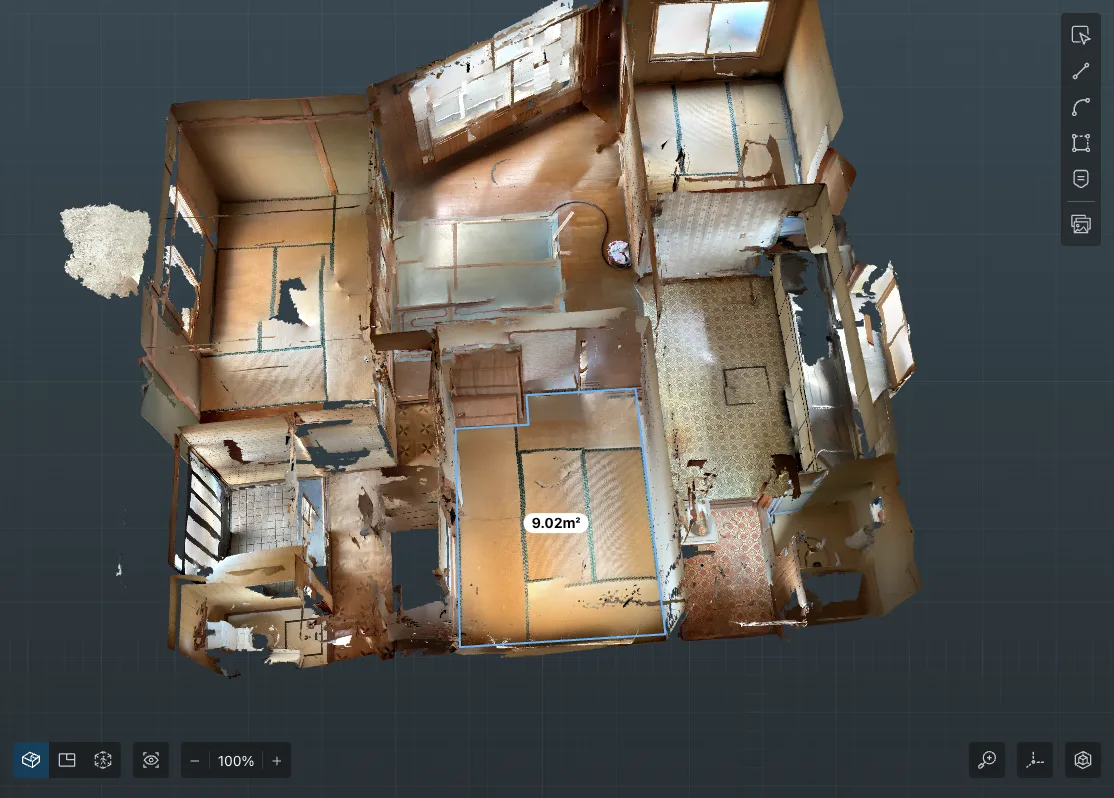
「部屋同士のつながりが分かりづらい」「必要な情報を後から探すのに時間がかかる」といった課題があり、結果として同じ現場への2〜3回以上の訪問(見落とし確認)が発生し、非効率な動きが生まれていました。
ScanatHow We Discovered It and Why We Adopted It
♦︎「屋外の広範囲」から「屋内の間取り」までスマホ1つで丸ごとデータ化
課題を解決する手段を探していた中、展示会でScanatと出会い導入を決定。
「iPadやiPhone1台ですぐに使える手軽さ」に加え、道路から私有地までの長い距離(50m程度)をいっぺんにスキャンできる広範囲な計測能力と、点群データをCADソフトにインポートできる拡張性が評価されました。
Benefits of Implementation
♦︎【新築】高低差測量の人員は2名→1名へ。作業時間は「1/5」に激減
Scanat導入により、新築の敷地測量のフローは一変しました。
道路から私有地まで50mほどある距離でも、Scanatなら「歩いて一気に撮影するだけ」で完了します。取得した点群データを出力し、3DCADソフトにインポートすることで、事務所のPC上で正確な高低差を算出できるようになりました。
その場での測量・計算が不要になり、機械の設置も必要ないため、従来2名以上で行っていた作業が「1名」で完結。作業効率は従来の「5分の1」にまで劇的に改善しています。
♦︎【新築・リノベ共通】見落とし防止で、現場確認〜提案の工数を約50%削減
新築・リノベ問わず、現場の見落とし確認にもScanatが絶大な効果を発揮しています。
細かい部分は現地で実測しつつも、大まかな空間把握やサッシのおおよその規格などはScanatのデータから読み取れるため、「現場を丸ごと持ち帰る」ことが可能に。
当初の目的であった見落としによる再訪問がゼロになり、現地確認〜提案までの全体工数が約50%削減されました。
♦︎【営業資料への活用】内覧会でのビフォーアフター共有
フルリノベーション物件の内覧会では、お客様に改修前の3Dデータをお見せして「ビフォー」の姿を体感していただいています。従来の360°カメラでは画角が限られ全体の雰囲気が掴みにくかったのに対し、Scanatなら「家全体の間取りや空間の繋がり」が立体的に伝わるため、提案の説得力と顧客満足度が大きく向上しました。
Future Outlook
♦︎”見えなくなる構造体”をデータ化し、新たな顧客体験へ
Scanatの導入により、敷地測量から現調、提案に至るまで、圧倒的な生産性向上が実現しました。
今後はさらなる活用法として、新築の「構造体が組み上がった段階」をScanatでスキャンし、各伏図と併せてデジタルデータとして保存することを構想されています。
完成内覧会を行う際に、「壁の裏側に隠れて見えない構造部分」をScanatのデータでお客様にご案内するなど、現場の3Dデータを活かした新たな付加価値の提供を検討していく方針です。
\ライフ・アーキ様も活用中!/
現地調査を「スマホ1つで・1人で」完結させるScanat